Plenty of people are asking the same question this fall. The 2026 wildfire season has carried smoke across much of the country, starting with the largest grass fire in Nebraska's recorded history in March and moving on to big fires in Utah and Colorado by late June.
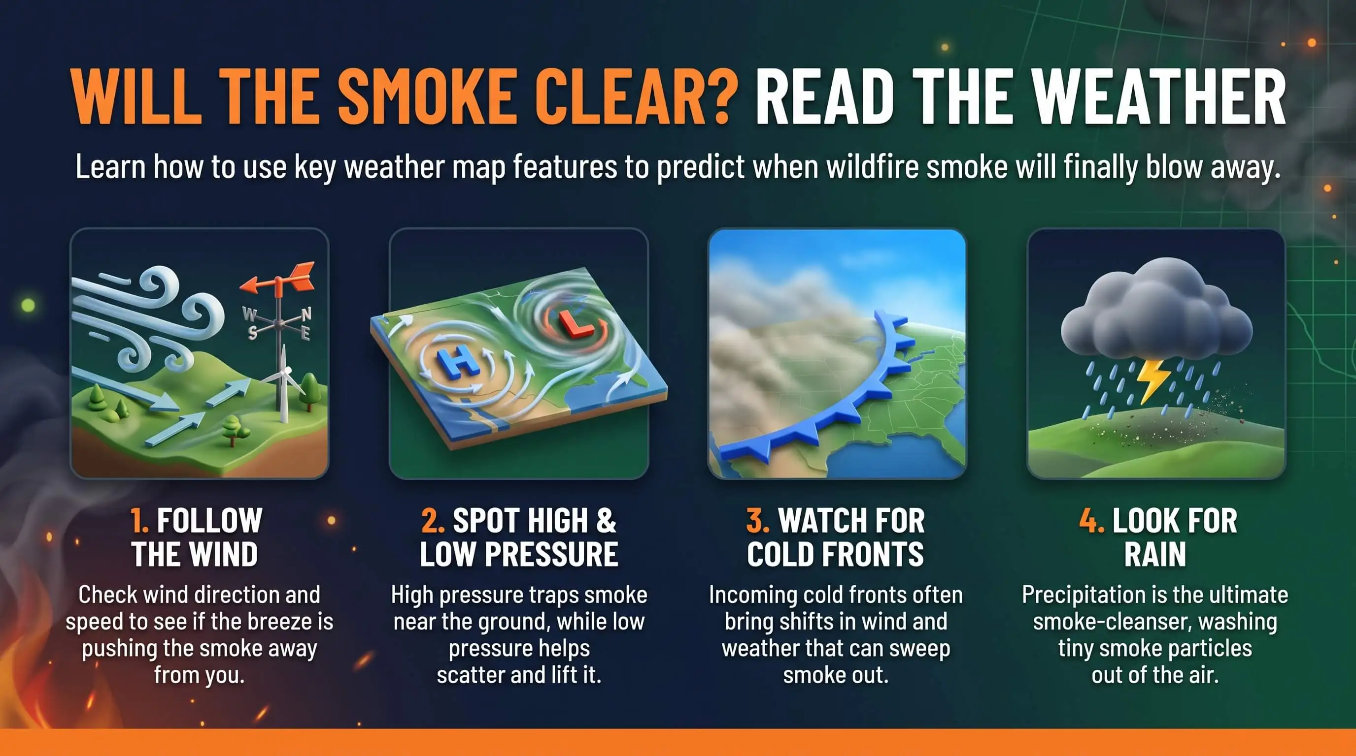
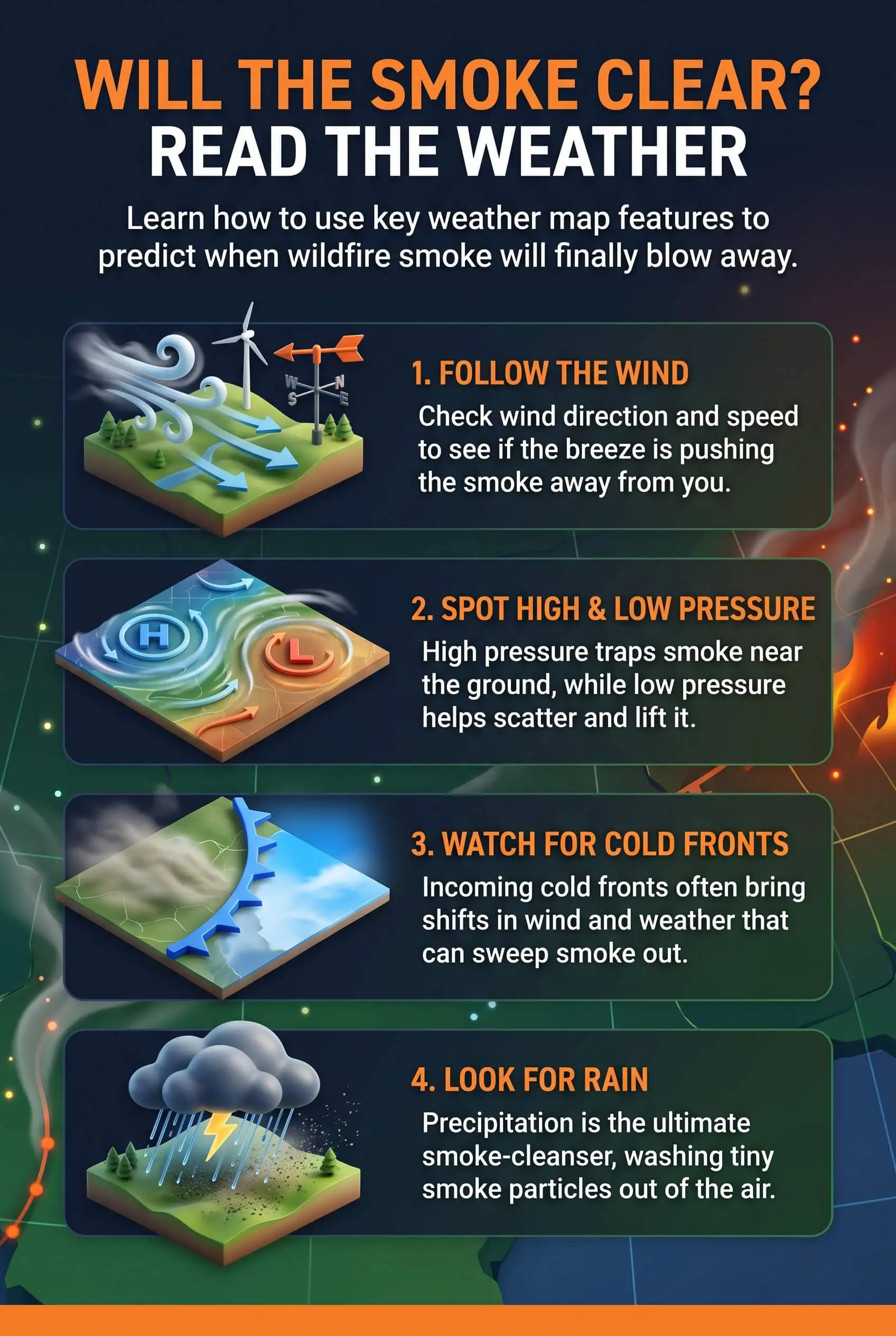
So can a weather map tell you when wildfire smoke will clear? Partly. Smoke forecast models estimate where smoke will drift about 48 hours out. The same weather maps also show the wind shifts, fronts, rain, and temperature inversions that decide when the air at ground level actually gets better.
TL;DR Quick Answers
current wildfire smoke map USA today
A current wildfire smoke map for the USA today layers three things on one screen: active fire locations, satellite smoke plumes from NOAA’s Hazard Mapping System, and ground-level AQI readings. Read the colored monitor nearest your home first. The gray plume shows smoke overhead, which may never reach the air you breathe.
Where to Look: The AirNow Fire and Smoke Map and national live trackers show fires, plumes, and air quality readings together.
What the Dots Mean: Green is Good up to 50 and yellow is Moderate up to 100. Orange starts at 101 and means Unhealthy for Sensitive Groups.
What the Gray Shading Means: Analysts trace smoke on satellite images and label it light, medium, or heavy. They can’t see it at night or through clouds.
Where the Smoke Is Headed: Drag the forecast slider. NOAA’s HRRR-Smoke runs look about 48 hours ahead.
What to Do at Orange: Don’t take your indoor air for granted. Close up, switch the fan to “On,” recirculate, and run a MERV 8 filter or the highest rating your system handles.
Top Takeaways
Forecasts reach about two days. Past the 48-hour window on NOAA's HRRR-Smoke runs, a smoke outlook is a rough guess.
Plume shading shows smoke overhead. Your nearest ground monitor shows what you're breathing.
Wind shifts, fronts, and rain clear smoke out. Look for them on the local forecast.
Calm high pressure and still nights hold it in. Inversions often make mornings the worst part of the day.
Indoor steps work right away. Recirculate, run the fan, and use MERV 13 where your system allows.
What a Weather Map Can and Can't Tell You About Smoke
Here's something that might surprise you: a map shaded with thick smoke can sit right on top of a neighborhood with decent air. Forecasters track smoke at two heights, and only one of them reaches your lungs.
Smoke Overhead vs. Smoke You Breathe
NOAA's HRRR-Smoke model forecasts both. Near-surface smoke is the concentration down where you live, and it drives health effects and poor visibility. Vertically integrated smoke counts everything in the air column, which NOAA's Global Systems Laboratory measures from the ground to about 16 miles up. The high smoke turns sunsets red. The low smoke is what pushes your local AQI up.
Why the Sky and the AQI Can Disagree
Haze and smoke smell both mislead. Smoke aloft can tint the sky for days without moving ground readings at all, while smoke trapped low overnight can foul the air before you notice a thing. When you want a straight answer, check a ground monitor.
How to Read a Current Wildfire Smoke Map for the USA Today
Most smoke maps stack three layers, and each one covers a different window of time. I start with a current wildfire smoke map for the USA today because it shows active fires, smoke plumes, and air quality readings on one screen. From there I work through the layers in order.
Satellite Plumes Show Where Smoke Has Been
That gray shading usually comes from NOAA's Hazard Mapping System. Trained analysts trace smoke on satellite images and label it light, medium, or heavy, so the layer records what already happened. They can't see smoke at night or through cloud cover. A blank map at dawn is no clean-air guarantee.
Forecast Models Show Where Smoke Is Going
This layer answers the question you came here with. HRRR-Smoke combines satellite readings of fire heat with forecast wind, rain, and temperature to project where smoke will travel, and its main daily runs look 48 hours ahead. Past two days, treat it as a rough guess. Drag the time slider and watch whether the smoke near you thins out, stalls, or builds.
Ground Monitors Show What You're Breathing Now
The colored dots measure air at breathing height. Green means Good, from 0 to 50, and yellow covers Moderate, from 51 to 100. Orange runs from 101 to 150 and means Unhealthy for Sensitive Groups. Red starts at 151. If a permanent monitor and a low-cost sensor disagree, go with the monitor.
Weather Signals That Smoke Is About to Clear
A Wind Shift or Cold Front
A new wind direction can shut off the smoke supply within hours. Cold fronts often bring that shift and push cleaner air in behind them.
Rain and Passing Storms
Steady rain washes fine particles out of the air, and a passing storm system stirs and mixes away much of what's left. A quick shower may only buy you a short break.
Afternoon Mixing
The sun warms the ground, the air near the surface rises, and it mixes with cleaner air above. That's why a rough 7 a.m. reading often looks better by early afternoon.
Weather Signals That Smoke Will Linger
Calm, Stagnant Weather
A strong ridge of high pressure brings light winds and slowly sinking air, which can build an inversion that holds smoke in place for days. Clear, still nights add a second lid. The ground cools fast, cool air settles beneath warmer air, and smoke stays pinned near the surface until mid-morning. Valleys get hit hardest.
Fires Still Burning Upwind
The weather can't clear smoke for good while the fire keeps making more. If the map still shows active fire detections upwind and the wind hasn't changed, count on any break being temporary.
A Five-Minute Daily Smoke Check
Open the live map and look for plumes and active fires upwind.
Drag the forecast slider out 24 to 48 hours to see which way the smoke is heading.
Check your nearest ground monitor before you trust the plume shading.
Read the local weather forecast for wind direction, fronts, and rain.
Decide on windows, outdoor plans, and indoor filtration for the day.
What to Do Indoors While You Wait
Don't take your indoor air for granted while you wait for the forecast to turn. These steps are fully in your hands:
Close windows and doors, and shut any fresh-air intake so your system recirculates the air already inside.
Switch the thermostat fan from "Auto" to "On" to keep air moving through the filter.
Use a MERV 13 filter, or the highest rating your system handles, which matches EPA guidance for smoke events.
Set up one clean room with a portable HEPA air cleaner where your family spends the most time.
Check the filter often and swap it once it turns gray or airflow drops.
Pro Tip: A filter can only clean air that actually passes through it, so the fan setting matters as much as the rating. To see how outdoor readings play out inside a house, read this guide to AQI, smoke, and indoor air.
When Is It Safe to Open the Windows Again?
Let the nearest ground monitor make this call, not a blue sky. I wait for green or yellow readings to hold through at least one full afternoon, with a forecast slider that shows no smoke drifting back in. It's also helpful to test indoor air quality before reopening windows to check whether fine smoke particles are still present inside your home.
"In my years reading smoke forecasts through western fire seasons, I've seen more people caught off guard by the morning inversion than by the fire itself. The sky clears by noon and the windows go up, then by evening the smoke settles back under the same lid. My advice is to wait until the forecast shows a wind shift, because a blue afternoon on its own doesn't tell you much."
7 Essential Resources
AirNow: How to Use the Fire and Smoke Map: The official walkthrough for every map layer.
EPA: Wildfire Smoke, A Guide for Public Health Officials: The 2026 federal smoke guide, with 14 companion fact sheets.
National Weather Service: HRRR Model Upgrade: The weather model that smoke forecasts build on.
FRAMES: AirNow Fire and Smoke Map Record: Who runs the map and where its data comes from.
Oregon Smoke Blog: How to Use the Fire and Smoke Map: A layer-by-layer reading guide from Oregon air agencies.
RAMP: EPA's Updated Wildfire Smoke Guide: What changed in the 2026 EPA guide, including clean room advice.
CAPCOA: AirNow Fire and Smoke Map: California air officers' overview of the map and its recommended actions.
These trusted resources from AirNow, the EPA, and other air quality agencies explain how to read wildfire smoke maps, understand smoke forecasts, and respond to changing air quality conditions. They also offer practical advice on reducing indoor smoke exposure, from keeping windows closed and creating cleaner indoor spaces to selecting top air filters that effectively capture fine particles during wildfire smoke events.
3 Supporting Statistics
The National Interagency Fire Center counted 64,393 wildfires and 9,032,816 acres burned in 2026 as of October 14. NIFC National Fire News
NOAA runs its 00, 06, 12, and 18Z HRRR-Smoke forecast cycles out to 48 hours. NOAA HRRR-Smoke Graphics
HRRR-Smoke pairs fire radiative power from polar-orbiting satellites with wind speed, rain, and temperature data, and it produces new forecasts four times a day. NASA Earth Observatory
With more than 64,000 wildfires and 9 million acres burned in the U.S. as of October 14, 2026, monitoring wildfire smoke remains important. NOAA's HRRR-Smoke model provides updated 48-hour forecasts four times daily, using satellite fire data and weather conditions to predict smoke movement. These forecasts help homeowners prepare for changing air quality by keeping windows closed when necessary and using high quality filters to capture fine smoke particles indoors.
Final Thoughts and Opinion
My honest take: the forecast slider judges smoke better than the view out your window does. No weather map can promise a clear day. What it can show you is whether the next 48 hours lean toward wind, rain, and mixing, or toward calm air that lets smoke sit.
The work that protects your family happens inside. Closed windows, a fan set to run, and a filter built for fine particles will do more for your lungs than any forecast, and that's where you get to be the hero of your household. Homeowners exploring air ionizer installation companies should also consider how these systems complement proper filtration and whether they produce ozone when managing indoor air quality during wildfire smoke events.
Frequently Asked Questions
How Far Ahead Can a Smoke Forecast Predict When Smoke Will Clear?
About two days. NOAA's main HRRR-Smoke runs reach 48 hours out, long enough to catch an incoming wind shift, front, or rain. Recheck the map every morning, since each new run can change the picture.
Why Is the Air Often Worse in the Morning During Smoke Events?
On clear, calm nights the ground cools and warmer air settles on top, trapping smoke near the surface. Once the sun heats the ground, usually by mid-morning, that inversion breaks up. Afternoon readings often look better as a result.
Does Rain Clear Wildfire Smoke?
It helps. Rain washes particles out, and a passing storm mixes the air. If fires keep burning upwind and the wind holds steady, though, smoke can drift right back in after the rain moves through.
Where Can I See a Current Wildfire Smoke Map for the USA Today?
National live maps and the AirNow Fire and Smoke Map show active fires, satellite smoke plumes, and air quality readings together. Switch on the plume layer, then check the colored monitor closest to your home before you make plans.
Why Does the Map Show Smoke When My AQI Is Good?
Plume shading covers smoke anywhere in the air column, often thousands of feet up. A green or yellow reading on your nearest monitor means most of that smoke is passing above you for now.
When Should I Change My Air Filter After a Smoke Event?
Look at it as soon as the event clears, and replace it if it's gray or airflow has dropped. During long smoky stretches, check it every week or two. The importance of properly sizing your AC unit also comes into play, as a correctly sized system helps maintain consistent airflow and effective filtration when wildfire smoke keeps windows closed.
Know When the Smoke Will Clear Before You Open the Windows
A weather map can't promise clean air, but it shows whether the next two days point toward clearing or more smoke. Check the smoke forecast and your nearest air monitor each morning, and let those two readings tell you when to open the windows. Understanding other sources of indoor air pollution can also help you maintain healthier air inside your home, even after outdoor smoke conditions improve.